Maori call this vast alpine wilderness, Ka Tiritiri o Te Moana, which means “Steep Peak of Glistening White.” The jagged mountain peaks of the Southern Alps rise sharply from the valley and are dusted with clean white snow that sparkles in the sunlight.
The park was established in 1929, but it was first surveyed in 1864 when Arthur Dobson was looking for a mountain pass where he could build a road to the Goldfields of West Canterbury. When the rail tunnel was built in 1923, it was the longest in the British Commonwealth.
There are many ways to explore this wild and beautiful park – whether you are driving along the incredibly scenic Great Alpine Highway or riding on the iconic TranzAlpine railway.
You’ll be spoiled for choice when it comes to hiking – there are countless trails leading to lookout points, lush waterfalls and mountain meadows strewn with pale wildflowers. From short 30 minute walks to longer day tramps into the backcountry, there’s a trail for everyone.
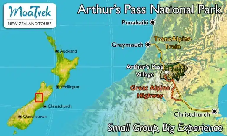
Where is Arthur’s Pass National Park?
Activities in Arthur’s Pass National Park
- Spot a Cheeky Kea: Arthur’s Pass National Park is one of the few places you can see the Kea – a native, and the only alpine parrot in the world. There are only around 5,000 of these beautiful and intelligent birds left in the wild.
- Temple Basin: Experienced skiers will love the challenging slopes at Temple Basin, an ungroomed paradise of snow-capped peaks and fluffy powder.
- Coast to Coast Race: You can watch the impressive Coast to Coast Race as it makes its way through the park. Cheer on the participants as they run, cycle and kayak through the wilderness.
- Alpine Flowers: From South Island Edelweiss to White violets to Yellow Snow Marguerite, the stunning alpine flowers blooming in the mountain meadows of Arthur’s Pass are a photographer’s dream.
Top 5 Walks and Hikes in Arthur’s Pass National Park
- Devil’s Punchbowl Waterfall: This is a short walk (1 hour return) with a very rewarding sight at the end – the falls cascading down a spectacular steep rock face in a lush mountain beech forest. It begins at the West Coast end of the Village and is marked with a signpost in the car-park.
- Bealey Valley Track: A 1.5 hour return hike, this easy track begins in a car park 3 km north of Arthur’s Pass Village. You’ll walk through peaceful forests to the base of Mount Rolleston and take the bridge across the Bealey River at “The Chasm.”
- Arthur’s Pass Walking Track: If you are up for a slightly longer hike, walking this path will take around 3.5 hours return and it will bring you through stunning alpine meadows to the summit of Arthur’s Pass. You’ll start from the same point as the Devil’s Punchbowl Waterfall walk.
- Avalanche Peak: This is a well-signposted walk to a beautiful summit. It will take around 6-8 hours return and the 1100m climb will reward you with gorgeous views of Mount Rolleston, Crow Glacier and mountains stretching as far as the eye can see.
- The Grand Tour: This walk combines several routes for a longer journey – joining the Punchbowl Falls, Dobson Nature Walk, Bealey Valley Track and Bridal Veil trails. It will take around 4-6 hours return.
Getting To & From Arthur’s Pass
You can reach Arthur’s Pass National Park via the incredibly scenic Great Alpine Highway – a spectacular drive from the Garden City of Christchurch. However, the mountain roads are winding and can test your nerves – so only attempt this if you are a confident driver.
A lot of people make the trip from Franz Josef on the west coast, to Christchurch in a day, meaning almost no time in Arthur’s Pass. We always stay in Punakaiki, which is much closer, giving you all the time you need to see all the stops on the way.
Or, you can catch the famous TranzAlpine railway. It’s possible to make a day trip to the park on the trail. You’ll get dropped off at 10:15am, the train will continue to Greymouth and will come back through Arthur’s Pass at 4:15pm. Note however that you’ll need to be on a tour or have an onward ride arranged, there are no transport or rental cars in Arthur’s Pass.
The nearest airports to Arthur’s Pass National Park are Hokitika Airport one hour drive away and Christchurch International Airport 1.5 hours away.
The Landscape and Climate
In the summer (December through March), you can expect mild and dry weather that becomes hotter (up to 35 degrees Celsius) into February. The best time of year to visit for hiking is spring or early summer.
During the winter months, from June through August, temperatures can range from -15 to +10 degrees C. Snow often starts to fall in late May. Winter is the time to visit if you want to incorporate skiing into your trip.
Arthur’s Pass Average Temperatures:
- Summer, December – February. High: 68F, 20C. Low: 52F, 11C.
- Autumn / Fall, March – May. High: 64F, 18C. Low: 45F, 7C.
- Winter, June – August. High: 54F, 12C. Low: 37F, 3C.
- Spring, September – November. High: 61F, 16C. Low: 43F, 6C.
Arthur’s Pass rainfall days:
The highest rainfalls months: December, June, October with an average of 17-19 rainfall days. The lowest rainfalls months: July, February, January with an average of 11-14 rainfall days.
Accommodation
There’s a full range of accommodation available in Arthur’s Pass National Park, from basic backpacker hostels to family-friendly campsites to luxurious hotels. For a little bit of peace and quiet, there are many places where you can rent self-contained cabins and cottages. You’ll also find lots of options in the small towns around the area, such as Otira and Bealey.
If you are looking for somewhere a bit more luxurious, Wilderness Lodge is a stylish and elegant hotel with gorgeous mountain views.
Local Information
When it comes to picking up groceries in Arthur’s Pass Village there isn’t a lot of selection and prices can be high, so we recommend you stock up in Greymouth, Hokitika and Christchurch before you arrive. If you are using a portable camping stove, it’s also a good idea to buy your fuel at a larger town before you arrive, as it can be hard to find in Arthur’s Pass Village.
The Arthur’s Pass National Park Visitor Centre is operated by the Department of Conservation and is a great place to stop in before a hike to get info, maps, track conditions and more.
If you’re travelling over the pass, the village itself is your Wifi oasis. Either side of Arthur’s Pass for an hour either side, there’s no coverage (accept at Castle Hill).
Visiting Arthur’s Pass National Park with MoaTrek
Our tours to Arthur’s Pass National Park highlight the best of this gorgeous region. The evening before we head over Arthur’s Pass we spend the night in Punakaiki and see the Pancake Rocks, palm trees and the sunset on the beach.
On our final day on tour we cross the alps to see alpine flowers and the spectacular views from the mountain passes along the Great Alpine Highway. We drive up the Otira Gorge on a cantilevered road through towering mountains to Arthur’s Pass National Park stopping at the lookout to watch the mischievous antics of the keas. Stretch your legs in the beech forests at Arthur’s Pass village and at the massive limestone rocks rising out of bare pasture at Castle Hill a natural limestone Stonehenge, with the chance to explore and discover something of the cultural heritage of this unique area before we descend Porter’s Pass to the Canterbury Plains and Christchurch.
There are a number of MoaTrek tours that include Arthur’s Pass National Park: